For boaters, understanding water depth is more than a matter of convenience—it’s about safety. Running aground can cause costly damage, disrupt a trip, or even put passengers at risk. That’s why many sailors and anglers now rely on a water depth app to track depths in real time and plan safer routes. When combined with tools like electronic nautical charts, these apps empower boaters with accurate, up-to-date information to avoid shallow areas and hidden hazards.
Why Knowing Water Depth Matters?
Depth awareness plays a critical role in navigation. Even experienced boaters can be caught off guard by shifting sandbars, submerged rocks, or sudden depth changes near coastal areas. A reliable system that constantly monitors water depth helps prevent accidents, ensures smoother journeys, and builds confidence when travelling in unfamiliar waters.
This proactive approach to on-water safety aligns perfectly with the mandatory Texas Boater Safety Course, which equips operators with formal training in accident prevention and skilled navigation.
The Basics of How a Water Depth App Works
Water depth apps typically use a combination of technologies to provide accurate data. These include:
- GPS Integration
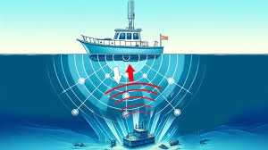
Most apps work in tandem with GPS, pinpointing your vessel’s exact location and overlaying it on digital charts. With this information, the app calculates depths relative to your current position. - Sonar or Depth Sounder Input
Some apps connect to onboard sonar or fishfinder systems. These devices send sound waves into the water, measure how long it takes for them to bounce back, and calculate the depth. The app then displays this data in real time. - Chart-Based Depth Data
Many water depth apps include preloaded bathymetric charts—maps that show underwater contours and depth readings. Even without sonar, boaters can see general depth patterns in the area. - Crowdsourced Information
Some platforms allow users to share depth readings they’ve collected, contributing to a shared database that benefits the boating community. This crowdsourced model helps identify new hazards or changes in waterways.
Key Features Boaters Should Look For
When choosing a water depth app, consider these features to ensure maximum reliability and usability:
- Offline Access: Essential for areas with poor connectivity, offline charts keep you informed even when cell signals disappear.
- Custom Depth Shading: Apps that highlight shallow zones in different colours make it easy to spot danger zones at a glance.
- Tide and Current Data: Depths change with tides, so apps that integrate tidal information provide more accurate readings.
- Compatibility with Onboard Devices: Look for apps that connect with GPS units, chartplotters, or sonar systems for real-time updates.
- User-Friendly Interface: An intuitive design ensures you can quickly access critical data when making navigation decisions.
Real-World Scenarios Where Water Depth Apps Help
- Navigating Shallow Bays
When exploring coastal areas, boaters can use depth shading to avoid running aground on sandbars or mudflats. - Fishing Offshore
Anglers often target depth-specific structures, such as drop-offs or reefs. A water depth app makes it easier to locate these areas. - Crossing Tidal Inlets
Depths at inlets change dramatically with tides. By integrating tide data, apps help boaters plan safe crossings. - Exploring Remote Lakes or Rivers
In areas where charts may be outdated, crowdsourced reports provide updated insights into shifting depths or submerged obstacles.
Popular Water Depth Apps on the Market
Several apps stand out for their reliability and features:
- Navionics Boating: Offers detailed bathymetric charts and customizable depth shading.
- C-MAP App: Known for high-resolution mapping and global coverage.
- iNavX: Supports multiple chart formats and integrates with onboard instruments.
- Aqua Map: User-friendly with offline chart support and crowd-sharing features.
Each has strengths, so the best choice depends on whether you prioritise fishing features, global coverage, or ease of use.
Balancing Technology with Seamanship
While apps are powerful tools, they should complement—not replace—traditional boating skills. Carrying paper charts, learning to read water conditions, and practising situational awareness remain vital. Think of a water depth app as an extra layer of protection rather than your only safeguard.
Conclusion
A water depth app combines GPS, sonar input, bathymetric charts, and sometimes community-driven updates to give boaters a clear picture of what lies beneath the surface. By providing real-time depth awareness, customizable alerts, and integration with tides and currents, these apps significantly reduce the risk of running aground. For recreational boaters and seasoned sailors alike, they are an essential tool for safer and more confident navigation.